Bering Strait
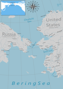
Strait between Asia and North AmericaThe Bering Strait is a strait between the Pacific and Arctic oceans, separating the Chukchi Peninsula of the Russian Far East from the Seward Peninsula of Alaska. The present Russia-United States maritime boundary is at 168° 58' 37" W longitude, slightly south of the Arctic Circle at about 65° 40' N latitude. The Strait is named after Vitus Bering, a Danish-born Russian explorer.
Read article
Top Questions
AI generatedMore questions
Nearby Places

Diomede, Alaska (town)
City in northwest Alaska

Diomede Islands
Islands between Alaska and Russia

Big Diomede Island
Island in the Bering Strait, territory of Russia

Little Diomede Island
Island in the Bering Strait off Alaska, U.S.

Bering Strait crossing
Proposed bridge or tunnel connection between Russia and Alaska


